
I may have briefly entertained the idea of riding the Sechura Desert, but in reality my sister Jo and I were always going to take the dirt road route into Peru through La Balsa. Once over the border I hadn’t put much thought into the terrain, rather assuming that the ups and down of Ecuador would continue. They didn’t, instead much of the first five days in Peru consisted of gentle and essentially quite dull riding. But this was no real bother, it was actually nice for once to get a sense of movement. A smile was also easier to maintain on those more utilitarian days knowing that there was plenty of fun to come. For one piece of topography I was aware of was a series of reasonably sized climbs and descents I call the Balsas Big Dipper. Starting in the town of Leymebamba and ending about 90 miles (145 km) later in Celendin, the Big Dipper was a dirt track I was desperate to ride. It is the real reason I’d taken our tour this way. With multi-day dirt road climbs through climates and environments having filled my dreams for a while, this short section was to mark the start of my Peruvian romance. This was what riding the Andes is supposed to be all about. And I wasn’t left disappointed, save for one vital factor… the route is no longer dirt!

View down on the ‘crux move’ of the entire Cuenca to Cajamarca route… the 28 mile (45 km), 7325 ft (2230 m) climb up from the Rio Maranon
A narrow strip of fresh asphalt carried us all the way from Leymebamba to the broader paved highway out of Celendin. At times no wider than a bicycle path it was generally devoid of traffic and made the cycling a lot quicker and easier than it could have been. The 37 mile (60 km), 9,300 ft. (2,800 m) descent down to the Rio Maranon was I suspect much faster and more comfortable for us on pavement than it probably was for previous riders on dirt. And the 28 mile (45 km), 7325 ft (2230 m) climb back out from the river was certainly easier. Despite this, Jo and I had decided to break the main climb up into two days in order to take the pressure off and ensure we enjoyed the experience. I call this approach ‘Casual Climbing’, a steady method of climbing I’ve developed in line with my ‘Sustainable Cycling’ ethos. I always cycle within myself, neither going as far as I could nor as fast as I can. This way I am able to cycle day after day after day without burnout. With the introduction of pavement to this climb however it is in reality certainly nothing more than a days work. Even with a relaxed approach and a start delayed by some heavy morning rain, we got most of the way up the ascent before pitching camp. Just one extra hour of daylight would probably have had us waking to the inside of a Celendin hotel the next day rather than to the magnificent views we actually enjoyed.

Route from Leymebamba south-west to Cajamarca…
click here to view the fully interactive map and elevation profile
Leymebamba to Cajamarca Route elevation profile
I can’t help feeling it’s a massive shame that such a classic dirt road route has now been paved. If only I’d been a year earlier I might have got to ride the dirt version. Although that said I could also have been riding a building site! Reading reports from other dirt road enthusiasts further south in the America’s I fear that I may be repeating this sentiment several times before my tour is up. However, I cannot begrudge people paved roads as it makes movement so much easier. The paving of this route down through Balsas means that buses are now able to run directly and safely through from Cajamarca to Chachapoyas, finally opening up a reliable transport network in the area. I’m personally glad of this bus too as I expect to be taking it in a couple of days on a backtrack from Cajamarca to visit the acclaimed pre-Inca fortress at Kuelap. Jo and I had always hoped to take a day to visit Kuelap but when the time came we kept riding, fearful of our time limitations. A frustrating decision in hindsight as the new pavement actually had us arriving in Cajamarca two days earlier than forecast. I am lucky that I can backtrack, Jo sadly can’t. We made it to Cajamarca in time for her to catch her flight out and as I write she’s settling back into life in the UK. So what follows is not only the story of the first of hopefully many big Peruvian climbs and descents for me, it’s also the final installment in Jo’s two month tour. So enjoy the little blonde on the road in these pictures as in future posts it’ll be back to photos of vacant roads…

Leaving Leymebamba the road circles up and around giving great views of the town

4 hours 25 minutes (plus lunch stop) and 18 miles (30 km) later we’ve climbed the 4,350 ft (1,325 m) up to the Calla Calla (aka Barro Negro) pass… as we arrive the clouds close in and the rain starts

As we descend south-west from the pass the clouds start to clear and we can see our narrow strip of asphalt winding along the mountain side

As the clouds lift a never-ending mountain vista appears to our right

Despite the hazy conditions we’re just able to make out the silver slither of the Rio Maranon., our days destination

Crossing over into a neighboring valley another portion of our grand descent reveals itself

Switchback on switchback… we’re slowly moving down into a desert environment

Having only summited the pass at 16:10 the light is starting to fail as the little town of Balsas comes into view huddled next to the river below

Arriving in Balsas in the dark we’re pointed towards the first of the two hospedaje’s in town… fortunately we hit Hospedaje Las Palmeras on a week night and the Bar disco remains dormant

Balsas is a strange little one street village where the tap water comes laden with silt straight from the river
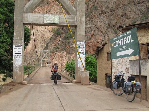
About a 2km backtrack to Chacanto we’re crossing the Rio Maranon and starting our climb

The mornings rain leaves as we start to ascend away from the river on a very recently paved road

The 28 mile (45 km) climb comes in four sections, the first of these takes us up through desert…

I adore the desert environment so our progress is slow as I stop every couple of minutes to examine something else that’s caught my eye

Deserts are often rich in flora and fauna…

… and the lack of resources mean the plant life is spaced out so different varieties are easy to spot

If anyone can tell me what this plant is I’d love to know. I’ve been seeing these flowers for a while and their beauty is something that always lifts me

I wonder if anyone has counted the number of switchbacks on this climb…

As we reach the end of the first section of climbing the vegetation is starting to get greener

Having woken up to heavy rain we start out late with no ambition to complete the climb in one day… this makes for a relaxed day of happy casual climbing

The second section of the climb takes us through small agricultural plots and homes… the road switchbacks across a water source for quite few turns

Then we turn south on a briefly straight course past the village of El Limon and into section three of the climb

Clouds have been hogging the slopes ahead all day so we have no idea where our route is going after we’ve negotiated…

… these broad switchbacks. It’s a slightly disheartening sight when these switchback come into view as it means the vista won’t be changing much in the foreseeable future

Miraculously the cloud clears for the first time all day as we reach the top of the switchbacks and the end of the third section of climbing. But in no time they’ve rolled in again and bought rain with them. Thunder echoes around the valley as we set about finding water and a camp spot

Heavy evening rain has us eating oats for dinner. It continues to rain hard for most of the night. Thankfully we wake up to a dry morning…

… and are able to enjoy more oats before the clouds come in again

Breaks in the clouds have me drawing my camera like a cowboy to capture views of the river below

As the route moves around to the north the previous days 5,800 ft (1,770 m) of climbing is revealed

24 hours previous we were riding desert, now we’re passing pine trees

As we continue to switchback up the temperature drops and it feels as if the clouds are in for good…

… but then another break…

… and we’re destined to top out the climb with views of where it started…

… zooming in on the Rio Maranon over 7,000 ft (2 vertical km) below, we can see our road snaking up both sides of the valley and Balsas nestled into the east side of the river (center-left of shot)

Once over the pass the view changes completely and we find ourselves looking down on Celendin

After the tranquil speed of prolonged climbing the quick 6 mile (10 km) zip down to Celendin brings quite a thrill. As does the appearance of a Chocolate shop on the road into town… of course we have to do our cyclists duty!

Celendin seems like a functional city. We stock up with food and ship out to find a lunch spot…

… on the way out of town the perfect place presents itself. With dark clouds looming a covered lunch looks to be on the cards. But as we settle in a load of kids appear and I’m in no mood to have people laughing and staring as I eat…

… close to the edge of town the rain arrives, evaporating in huge clouds as it hits the hot asphalt

I’m full on h-angry (thanks for your patience Jo) by the time we eventually find a covered spot to sit and eat. The rain keeps us captive there for quite some while before we start our afternoons climbing up to the Loma El Indio pass

By camp o’clock our options are looking limited and the rain is closing in again. Fortunately with the blessing of the people living across the street we find an empty building to settle behind…

… complete with a covered area for us to cook (and mend punctures) safe from the lashing rain

Next morning we join the locals and their animals on the road to Cajamarca. The area has a great system of local milk processing facilities where people take their daily production by donkey. Once the milk is off loaded it appears that many of these donkeys are left to lake their own way home… these two didn’t seem to be going anywhere fast

As we climb up towards the Gran Chimu pass (12,000 ft, 3,620 m) the landscape becomes very reminiscent of the English Lakes (minus sheep)

Then we’re descending again. This time on the only remaining stretch of unpaved road between Chachapoya and Cajamarca. But it doesn’t last long, the asphalt soon resuming to deliver us down to lunch in Encanada…

… the thought of lunch gets Jo confused as to where her handlebars are

Double bike portrait in Encanada… Shermy’s last day with a bike buddy

After Encanada the landscape broadens into a lush green valley…

… before dropping down into Cajamarca and the end of Jo’s bike journey

Your white mystery flower is sometimes called, “Angel’s Trumpet” or “Moonflower.” It is in the genus Datura. I have often grown them in Fife Lake! They like hot days and cool nights. It is a beautiful flower, and I remember seeing them growing wild in New Mexico.
Loved these latest photos from Peru, especially the pictures of desert flowers, and the mountains!
Marilyn
Thanks Marilyn,
In some places I’ve seen huge bushes of them, they’re really quite stunning. So pristine.