
Volcan Chimborazo not only stands proud at as Ecuador’s highest point, its summit also happens to be the furthest point on the Earths surface from its centre. At 20,564 ft (6,268 metres) Chimborazo is by no means anywhere near approaching the league of big mountains, instead it achieves this distinction by its canny position on the Earths equatorial bulge. This is an interesting fact, but perhaps more interesting (for adventure cyclists) is the fact that there is a cheeky little route running between this volcanic beast and its northern neighbor, Carihuairazo (16,470 ft, 5020 m). My sister Jo and I had planned to take this route as a continuation of a course from Quilotoa through Simiatug to Riobamba. Unfortunately this was not to be when mechanical issues forced us back to Latacunga. Instead we ended up using this charming little piece of dirt riding/pushing as a quick but interesting route from Latacunga to Riobamba. For us, the section between the volcanoes was the extremely juicy filling between two dull and dry pieces of highway.

Three cheeky little chappies from Escuela Manuela Canizates
In my last post I complained about how the children around Quilotoa had almost been turned into commodities by the influx of tourism into the area. I compared them to the excitable and curious children that I often find away from the Gringo trail. It just so happens that Jo and I tapped into a rich vein of these adorable little rogues when we stopped for lunch at the start of the dirt section of this ride. Accordingly, the enduring memory of the four days from Latacunga to Riobamba won’t be the tremendous views of the highest point in Ecuador or the exhilarating riding, instead it’ll be of the eighteen grubby little kids that engulfed us that lunchtime. The true beauty of the interaction was that I’m sure it will live with the children as long as it lives with us… and not one of them asked us for anything.

Due to unfavorable weather we weren’t granted a real look at Chimborazo until we’d already ridden beneath her. Even in the evening gloom the eventual views were well worth the wait
It only really took a day to ride the dirt section between Chimborazo and Carihuairazo but it was one of those rides where it made me extraordinarily happy to travel by bicycle. Adventuring into these kind of landscapes is nothing short of a rare and beautiful privilege. Even when the weather isn’t so good and the views obscured, the plants at your feet, the sounds and smells around you and the thump of your heart in your chest make these places special. It can be hard work hauling a loaded bike through bogs and up muddy tracks, but the harder the work the more frequent the rests and the more frequent the rests the more time to lift the head and drink in the real reason why you’re there. So thank you to my bike Shermy for being so bloody strong and helping me explore the places I want to experience.

After a quick zip down the PanAm from Latacunga we hit Ambato and start to climb

To the south-east Volcan Tungurahua smolders

A comfortable night camped on a friendly family finca…

… and the next morning it’s back onto the Ambato-Guaranda highway

The highway takes us up into the paramos, past the two-headed Llamas…

… and onto the turn east between Carihuairazo and Chimborazo. A yellow church and this obvious sign mark the intersection… we go the opposite way to the sign points

At the intersection we shelter behind a disused building to cook up some lunch… we’re soon joined by some curious children from the school across the road

Their numbers quickly swell until we have 18 curious little helpers

They’re great kids and it’s immense fun talking and joking around with them. Then Jo breaks out the bag of strawberry’s a friendly lady donated us the day before and we’ve got friends for life

Mmmm… strawberry’s

munch munch…

Many kids in the countryside are often dressed similarly to the adults giving them the appearance of little people older than they actually are

For the first time in her life Jo feels tall!

Soon it’s time to wrestle back our belongings and get back on the bikes

Looking back it’s a good feeling to leave the hard-top behind and be back on dirt

Unfortunately heavy skies mean we still haven’t really seen the volcanoes

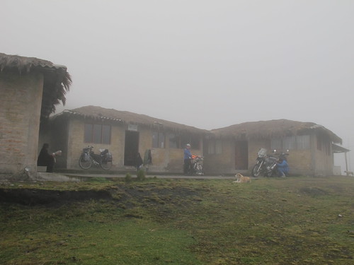
After about 5 km on dirt we reach the community owned cabanas. With rain closing in we decide (after much deliberating on my part) to fork out the $15 for us both to stay the night

Although unheated (there is a heated option next door at $12 each) our cabana has space, a kitchen, perpetually running water and is proves surprisingly cosy

After a good night sleep I wake up to an awesome view of Chimborazo. By the time I get my camera the clouds have closed in… we’re offered just one fleeting view before the clouds descend for the day
So it’s in cold wet cloud that we depart the cabana…

… leaving our Colombian neighbors Samuel and Juan struggling to get one of their BMW’s started. They’re travelling from NJ, USA to Argentina

Off we head into the abyss… past a sign reading ‘Senderos Ciclismo Turistico’ (tourist biking trails)

There isn’t far to climb from the cabanas but on treacle sticky mud above 14,000 ft it gets the heart pumping a little

We’re soon at the high-point around 14,370 ft (4,380 m). These days I’m riding with a Suunto Vector watch to compliment my bike computer, this offers me the addition of cumulative descent figures and more reliable elevation readings

As the descent starts we’re both keen to get down to warmer climes

Soon the clouds begin to thin and we’re able to enjoy some fun downhill trail…

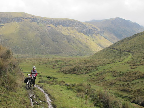
… and when the valley opens up, some terrific views

But the easy riding is soon behind us and we get stuck into some pushing…

… and pulling…

… interspersed with short stretches of single-track…

… and some bog avoiding freestyling

At one point we’re joined by an enormous bird who circles around us waiting for the mud to catch him some lunch

Gaps are starting to appear in the clouds letting appreciated flashes of sunlight in

We drop down to the valley bottom…

… where I bite off a bit more than I can chew on my chosen route over the stream
Then we’re back to pushing, up away from the valley floor

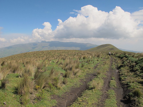
The climb is manageable to start as we push towards our first views of Carihuairazo

But soon the trail is so steep and deeply rutted that we have to take the panniers off to even push the bike up

Things get a bit easier, but there’s still a predominance of challenging pushing

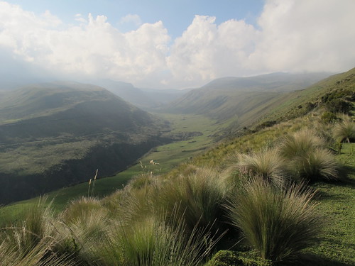
It’s worth it though as the climb takes us back up above the beautiful valley…

… to a vantage point from where we can look down on the road to Urbina we’d planned to take
We climb up onto the northern ridge of the Rio Mocha valley…

… and enjoy the amazing views all around. To the east Volcan Tungurahua is going off in a big way

We drop over the north-eastern side of the ridge and take farm tracks around…

… until we’re looking down on the PanAm highway…
… before making it all the way around to the head of the Mocha valley…

… from where a series of farm tracks takes us down to and across the Rio Mocha

As we climb up away from the river towards joining the cobbled road south to Urbina, Chimborazo clears for the first time

Our amazing day of dirt ended with a miserable run down the PanAm in the dark. After a night in San Andres it was only a quick roll the next morning into Riobamba and the chance to wash a serious coating of grime off our bikes
Route Tips
As is often the case we got the bare bones of our route information from Cass Gilbert, see his relevant post here. However, we approached the turning off from the Ambato-Guaranda highway from the opposite direction and followed a different route to Urbina. In regards to finding the turn off the highway it was a bit difficult to see the Escuela Manuela Canizates Cass mentions when coming from the north, so it’s worth looking out for the yellow church in my photograph above. Just make sure you take the turning away from the church and not towards Cunuyacu. There is a working tap just outside the church.
On route the trail is obvious, running past the cabanas and down into the valley. Having descended into the valley there is a shepherd’s hut and a small stream to cross (6 miles or 9.5 km from the cabanas). Cass went freestyling from here and advises against copying him, instead he suggests climbing the hill and then dropping down to cross the Rio Mocha and reach the road to Urbina. We went up the hill as advised but found no easy way to drop down to the river. However, this is no bad thing as the trail climbs up onto a stunning piece of ridge on the north side of the Mocha valley.
Once over the ridge and dropping down the north side there will be a junction of farm tracks (about 9.75 miles or nearly 16 km from the cabanas). Take a right here and then the upper of the two tracks you can see from this first junction (the one going up over the hill). This will bring you back around into the Mocha valley. There may be a way down from here into the valley to join the Urbina road Cass talks about but I haven’t ridden it so can’t be sure. We vaulted the gate and took a series of farm tracks east down towards the river. As you get near the river you’ll have to turn north along the valley where the road descends to cross the water before heading up and south. This will take you onto the road towards Urbina. Continue south down this road, over the railway line to Urbina. Urbina only consists of the railway station and a posada/cafe/restaurant which was closed when we arrived.
This route involves a fair amount of pushing and shoving through deep mud. It wasn’t unusual for the bike to sink up to the bottom bracket. It crossed my mind whilst out on trail that this would be a difficult route to take if you ride low-rider front racks. Things may be different in the dry season and although I thought this worth mentioning, I wouldn’t let it put you off.

Pingback: Dusting Down to Ayacucho | Velo Freedom - Cycling South·