
Oh how I’ve fallen for the Colombian Cordillera Oriental. It lifts me up, it brings me down, it lifts me up, it brings me down, it lifts… you get the picture. This South American mountain riding is more than just good fun, it’s an absolute joy. Everyday brings promises of new challenges, every pass a new vista and every turn a release of excited anticipation. I feel blessed that over the coming months the mountains are only going to get bigger, the highs higher and the involvement more intense. And I say all this having just taken the easy way from Pamplona to Villa de Leyva.

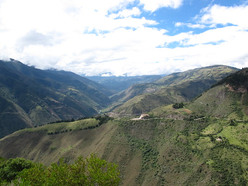
Looking over the Chioamococha Canyon towards El Cocuy National Park
Setting off out of Pamplona I dreamt of the untamed high mountain roads bordering El Cocuy National Park. Climbing out of town on Highway 55 accompanied by throngs of Saturday morning cyclists and lycra clad inline skaters I couldn’t shake the slight disappointment at having to ride a ‘highway’. Thankfully I soon rid myself of this unhelpful attitude and opened my mind to the discovery that the 55 is quite unlike what I expected. It is as much paved as it is unpaved and as undulating as it is vacant of traffic. As the days added up and inertia mounted the 55 quietly nuzzled its way into my affections and became a trusted ally.

Camped above 12,000 feet in the páramo before Cerrito
Just before leaving Pamplona I received the fantastically exciting news that my sister has booked flights and will be packing one of her bikes to meet me early January in Quito, Ecuador. It is this news that persuaded me away from my proposed indulgences in the Boyaca highlands. Having a commitment down the road means that for the time being I have to dilute the tendency to explore with the need to progress. Something I’m happy to do in view of what I’m sacrificing for. That said, there was still a tinge of disappointment as I looked out across the Chioamocha Canyon at the start of the route I coveted through La Uvita, Chita and Jerico. Snaking relentlessly up out of the canyon, it looked even more magnificent than I’d ever imagined. I really hope someone rides it soon and posts the details.

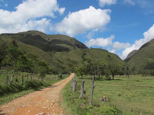
Riding down the valley towards Gambita near the end of the route after leaving the 55
So on this leg of the journey I found myself striking a happy balance between progress and exploration. And with that balance came a little bit of everything. I rode enough difficult dirt roads to maintain a connection with the land and it’s people but also enjoyed the feeling of fluidity and distance that comes with sweeping through the topography on a more established road. All in all the route was fun, incredibly varied and in essence quite rewarding.
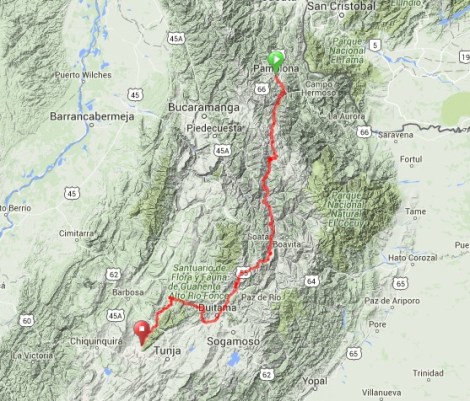
Route from Pamplona to Villa de Leyva… click here to view the fully interactive map, elevation profile and download the GPX track
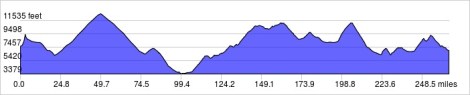
Elevation profile from Pamplona to Villa de Leyva
The 55 took me up to 12,600 feet and into the páramo, a beautifully barren ecosystem that fills the gap between tree line and snow line. A night camped in this peculiar void left ice in my water bottles and images of a bright full moon imprinted on my mind. The road then plunged down into the sweaty heat and cacti of the Canon del Chioamococha before once again pulling up towards the heavens, this time into a riot of stunning vistas. Across the canyon, El Cocuy’s bold jumble of high peaks taunted my inner adventurer. Solitary days hiking under snow-capped peaks and around bright blue Alpine lakes called but were resisted. Instead I let the faithful 55 suck me back up into the dark rain-clouds of the páramo and spit me out into the broad agricultural bowl around Belen. Momentum then quickly gathered down hill through the urbanity of Duitama.

Looking back at Pamplona as I climb away to start this latest leg of cycling
After the initial climb the road descends down to the Rio Caraba

Then after a night in Chitaga it’s a 13.5 mile and 3,100 ft climb up to Presidente

After Presidente the pavement ends leaving cows and cyclists to eat lorry dust

Climbing higher and higher great views open of the valley I’m ascending

The higher I climb the more otherworldly the landscape becomes

Until the first pass is crested and páramo opens up

After 21 miles and 4,751 ft of climbing a monument marks the high-point of the route, about 12,670 ft elevation

The altitude affords extraordinary views of the surrounding landscape

From the high-point the descent starts with a gentle ride through the páramo. The only company comes from an occasional convoy of lorries with their accompanying dust clouds

The formation of storm clouds in the valley below are enough to convince me to camp up in the páramo at 12,000 ft.

The páramo brings browns and greens and quite distinctive vegetation

After a beautiful nights camp the descent starts with this shrine to the Virgin Mary. There are many of these vehicle orientated shrine about, all designed to afford drivers divine protection

Before long the road turns to concrete, snaking steeply down into the town of Cerrito

As I pass through Concepcion there’s a town celebration going on complete with traditional dancers

People of all ages are dancing, although some look to be enjoying it more than others

After a night in Malaga the morning starts with a long descent into the heat of the Chioamococha Canyon

Much of the road to Capitanejo was under construction, it’ll soon all be concrete

Lazy and warm, Capitanejo is the epitome of sleepy

Once through Capitanejo I leave Santander and enter the Department of Boyaca

From Capitanejo in the Canyon bottom the only way it up

Having dropped down to lower elevations the flora has become decidedly prickly

The higher I climb the more incredible the canyon reveals itself to be

Every turn brings a new and exciting view

Colombia’s highest mountains sit just beyond the left side of the canyon as seen here. The landscapes are accordingly big, bold and stunningly beautiful

Soata surprises me with its architecture and feel so I decide to spend the night

From Soata I can look down on the start of the route I had hoped to take. From the canyon bottom it snakes up through the shadows on the left into the high mountains

Leaving Soata the next morning marks the start of another notable climb

The climb out of Soata lasts almost 4:30, 22 miles and 4265 ft. gained

Near the top of the climb sits this enormous and quite obnoxious shrine

After the shrine it’s a short climb up to the pass

Once the pass is crested the world changes immediately into more grass páramo

Black clouds come in quickly and ensure the remainder of my day to Belen is a wet one

I really cannot get enough of the páramo, which is good as I’ll being seeing a lot more of it

Leaving Belen the next morning the cold rains of the previous day are just a memory

Belen sits in this broad agricultural bowl

After climbing out of the bowl from Belen, it’s a quick downhill burst into the bigger city ‘delights’ of Duitama

In Duitama they were putting up the years Christmas decorations

Leaving Duitama the 55 has changed beyond all recognition. A four lane highway has appeared complete with traffic and boredom
After Duitama the 55 became a different animal, unpaved dusty climbs and solitary semi-paved meanderings giving way to four lanes of split carriageway. Enduring just a few miles of this mundanity I turned north-west from the town of Paipa to allow myself the indulgence of a little dirt road adventure. Once again the páramo beckoned as I steeply climbed into the rain. But as sure as the afternoons would bring rain the mornings summoned blue skies and shining sun. A magical creep down rocky dirt, through sleepy Palermo and I found myself bumping through a glorious stretch of tight V-shaped valley. Then, turning south in Gambita the traffic free track carried me up to Arcabuco from where it continued to climb into the afternoon downpours. A final ascent between increasingly lavish villas and I wound up in the enormous main square of Villa de Leyva. A bizarre colonial museum piece slightly tainted by the reek of money, Villa de Leyva is a little uncomfortably preserved for me. So I have retreated up the mountainside to camp at Hostal Renacer and plan my way to Bogota.

The road from Paipa climbed quickly and steeply soon revealing views of the town below

I’m surprised to find the first part of the climb to be paved

Local Paipa cyclist Felix Acosta Largo joins me for the first part of the climb. He never quite gets over how I can get such a loaded bike uphill

About two-thirds of the way up the pavement ends and I lose Felix

The temperature drops considerably as I hit the summit

As the descent starts I’m soon in the clouds and soon after that the rain

Thankfully a Finca owner lets me pitch up next to his house giving me shelter to cook under

The descent continues the next morning. The rocky road mean I descend about the same speed as I was climbing the previous day

After only 5 miles I give my forearms a rest from the brakes with a break in the sedate little village of Palermo

The stretch from Palermo to Gambita it probably the most enjoyable of the whole route
The road is often rough as it snakes through grazing land…

… past impressive waterfalls…

… and deeper into a narrowing valley

After a while the road climbs out of one valley and over into another

After lunch in the town of Gambita I climb about 1,000 ft. before the rain comes in

Once again I retreat from the rain to a finca where the owners feed me and let me pitch up next to the house

The final days riding starts with miles of really rough dirt. This road sees so little traffic the road had grassed over in places. With the previous afternoons rain some of it was quite hard work

But the patches of good dirt provided the opportunity to lift the head and take in the scenery

The tiny village of La Palma doesn’t quite know what to make of me

From La Palma it’s another climb up to Arcabuco. Most of the land in this area is given over to cattle so the road is lined with the days milk production. The milk van is the only traffic I see all the way to Arcabuco

From Arcabuci there is two roads to Villa de Leyva. The paved option runs 25 km around a mountain on a flat course. But the option I take is the unpaved road that runs 22 km straight over the mountain. It rains the whole way to Villa de Leyva

As I descend down into Villa de Leyva the rain stops and I’m soon standing in the cobbled Plaza Mayor, said by some to be the largest in Colombia. Villa de Leyva is where this leg ends and my journey to Bogota will begin.

Gob-smackingly fab pics of the Columbian highlands in this post…I really think the region contains some of the most beautiful scenery we have seen so far….love your description of VDL 🙂 Good luck with your ride to Bogota…a city I’ve totally fallen in love with.
Pingback: Riding a bicycle with a brain – Duitama to Palermo | Nick's Bike Tour·
muy bueno tu blog… vamos a hacerla con una amiga estos días .. gracias por la información .. buena aventura!