
On July 10th, 2013 I touched down in England after three years and three months away. Ahead lay three months of holiday, exploration and the chance to sort a number of things out. Liz came with me on her first trip to Europe and together we adventured through England, Scotland and France. Over six incredible weeks we crammed in all the sites and tourist attractions we could. In England we visited Windsor Castle, Stonehenge, Glastonbury, the Lake District and the numerous delights of London. In Scotland we took in Edinburgh, Oban and Fort William. Then in France we toured Paris, Dijon, the Burgundy wine region, Chamonix, Lake Annecy, Provence and Nice. The experience was terrific, packing our photo albums with iconic places and spaces and our minds with memories of one of the best summers imaginable.

Having seen more of her country than most US citizens it was a genuine privilege to have the opportunity to show Liz some of the best parts of the UK
My love of the outdoors started in the Lake District. We’d regularly visit its unique landscape as a family when I was young and as I got older I’d take myself up there to escape and absorb. The region instilled in me a love of hiking and landscapes that eventually led to a passion for cycle touring. So the chance to take Liz to a place I consider my spiritual home was a dream come true. But this was not the only place we hiked, in fact half our holiday was given over to hiking. And it is those walks that I will focus on here.
South West Coast Path, England
The South West Coast Path runs for 630 miles around the south-west tip of England. The longest trail in the country it runs from Minehead, Somerset in the north, around the coast of Devon and Cornwall to finish in Poole Harbour, Dorset. With our time under pressure we were only able to hike three days on the trail but that was enough to experience the beauty of the English coastline. Blessed with glorious weather and the company of my close friends Alex and Katie this was a stunning few days hiking.

We started walking just east of Plymouth, near Newton Ferrers
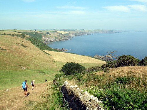
Within no time we were riding the steep rollercoaster of hills

Most farmland was grazing but there was variation

Crossing of the river Erme had to be timed with the tides

Our evenings camp spot at Bigbury-on-Sea gradually came into view

On Day 2 the first task was a hike down to cross the River Avon. The estuary looked gorgeous in the morning light.

We then took a small boat across the River Avon to Bantham

After stopping for a Cider in Hope Cove we carried on in search of a beach and a swim. This little beauty is what we found

We hiked inland to camp on our second night before heading into Salcombe for breakfast. Then we needed another boat to cross the Kingsbridge Estuary and get back to fantastic bays and coves

At the end of Day 3 it was time to head inland again and pick up the car at East Prawl
The Lake District, England
No visit to the UK would be complete without at least a couple of days hiking in the Lakes. Unfortunately that is all we got as the weather turned on our planned third walking day. Still, we managed two fantastic days walking. First we climbed Great Gable from Seathwaite via Styhead Tarn, descending via Green Gable.
Leaving Seathwaite behind we first headed south along Styhead Gill

Styhead Gill leads up to Styhead Tarn behind which towers Scarfell Pike

We then climbed steeply up from Styhead Tarn to the summit of Great Gable

On the summit we joined others having lunch overlooking Borrowdale

On the way back to Seathwaite we ascended Green Gable. A summit that affords dramatic views down Ennerdale

From Green Gable all that was left was to descend via Gillercomb to Seathwaite
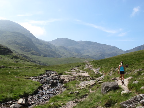
Our second Lakeland day hike involved scaling Helvellyn from our camp in Glenridding. At 3,117 ft Helvellyn is the third highest peak in England. Our route took us up over the iconic Striding Edge and down via Glenridding Common.

Climbing out of Glenridding we were soon leaving Ullswater behind

Ascending over Little Cove and heading west Red Tarn came into view, with the summit ridge of Helvellyn behind it

To reach the summit ridge we elected to clamber along the spine of Striding Edge

As we ascended up Striding Edge, Red Tarn dropped away beneath us

Until we reached the summit ridge and were able to look down on Striding Edge and Red Tarn

Reaching the summit we had our photo taken in front of Swirral Edge

Then it was back down to Glenridding via Keppel Cove
Ben Nevis, Scotland
Although I hiked in Scotland when I was younger I had never climbed Ben Nevis. At 1344 ft, ‘The Ben’ is the highest mountain in the UK. The reason I’d never climbed it is because so many other people want to. This leads to big crowds, a phenomena that we witnessed in full force. The incredible amount of people climbing the mountain with us made it quite a unique experience and actually quite fun. Our route took us up the tourist trail from the River Nevis via Lochan Meall an t-Suidhe. In the main we descended the same path.

The day before climbing Ben Nevis we took a short walk around Cow Hill and were afforded this magnificent view of The Ben itself

Our first task on the hike up Ben Nevis was to climb out of the valley, away from the River Nevis

After some quite steep climbing the path became shallower near the Lochan. The entire path up the mountain was saturated with other walkers

Climbing up away from Lochan Meall an t-Suidhe the clouds cleared revealing incredible views

After about three hours walking we reached the summit. This is the first mountain I have ever been on where it’s necessary to queue to reach the summit propper

Having taken our turn in the summit queue we bagged the obligatory summit photo

The gaggle of people on the top of Ben Nevis’ steep north face mark the summit. Although the vast majority of people take the route we did there is another side to Ben Nevis. The north and east sides of the mountain offer up challenging and exciting climbing and mountaineering.

Descending back the way we came we slowly moved back towards the vegetation line

On descent Loch Eil looked majestic behind Lochan Meall

Heading down from the Lochan the crowds seemed to have dispersed a little and the sun came out

Soon we were heading back down to the River Nevis and a good if slightly bizarre days hiking was done
The Alps, France
After hiking in England and Scotland the scale of the French Alps really takes the breath away. Our hiking plans in the Alps were partially thwarted by the weather. Having hoped to do a couple of longer day hikes out of Chamonix we chanced upon a period of wet and cold weather that meant we were reduced to staying low in the valley. Still, it was a treat when the clouds periodically cleared to give us views of the Mont Blanc Massif and the legendary Grandes Jorasses. At 15,781 ft Mont Blanc is the highest mountain in Europe.

The evening we arrived in Chamonix we were lucky enough to get views of Mont Blanc

Although we didn’t really get to hike around Chamonix, it is always a beautiful area to visit
After Chamonix we headed down for a coupe of days near Lake Annecy. Here the weather was much kinder and we were able to head out on the trails again. Our first hike out of Annecy involved a loop up Mont Veyrier and Mont Baron and down to return along the lake. The ridge connecting these summits offered superb views of the Lake and beyond.

Our first task on the way to Col des Sauts was to ascend quickly out of Annecy

We soon found ourselves in the cloud and summitted Mont Veyrier without a view. But eventually we got lucky as the clouds cleared and Annecy came into view

Looking south along Lake Annecy it is easy to see why so many people are attracted to this area. We climbed over this peak to descend down to the lake
Our second hike in the Annecy area was without question the pick of the bunch. I found a route on the internet that would take us on a loop up to the summit of La Tournette, at 7,713 ft. the highest mountain around Annecy. We started just below Chalet de l’Aulp and enjoyed the main route to the summit. This was in the company of quite a few other hikers and involved some fun with chains and ladders. Once we’d summitted we carried on south on a route down to Montmin and then north through the forest towards where we started. Fortunately the crowds went back down the way they had ascended and we were afforded our own little bit of Alpine paradise.

As we started hiking it was hard to make out where the route would take us

Within no time clouds had come in and we hiked virtually blind until they cleared again and this incredible vista presented itself

Some of the sections up La Tournette are quite scrambley. Things are made safe and easy by a network of bolted chains and ladders

The summit of La Tournette is on top of this giant block, quite unique in my experience

This Ibex was one of many we encountered on the route

Having reached the summit and enjoyed the views it was time to lose the crowds

Looking back at the mountain as we descended it seemed to get more majestic with every step

We were both on such a massive high from the views and solitude

Fantastic rock formations towered in every direction

La Tournette looked resplendent as the sun hit it and the ridge we’d just descended down

Alpine wild flowers and clear crisp sunlight gave us the Alps of our dreams

As we descended the path constantly surprised us, picking a route through the most glorious topography

Soon trees started to appear and we were left with a forest walk up the valley from Montmin to our start point
Within a week of leaving the Alps I found myself back at my parents house in Reading, England. I had a few days there to prepare for another longer hike. My Dad and I were about to embark on a 200 mile hike across England on Alfred Wainwright’s famous Coast-to-Coast trail. All this hiking around Europe was just a warm-up!
