
For the full photo diary of this part of the tour please click here
The past nine days of riding have confirmed what I already suspected; Guatemala is a premier cycle touring destination. It’s been a while since I strung together so many consecutive days on the bike and with the mountain topography of Guatemala it has undoubtedly been a touch tiring, but our route west has been 268 miles of varied and exciting riding. Having already cycled east across country on the Huehuetenango to Coban and then Coban to Rio Dulce via Fray Bartolome and Modesto Mendez routes, some of our course decisions were already made up for us, others would be decided along the way. As a result we’ve enjoyed riding some great dirt roads, enjoyed/endured pushing our gear up some other spectacular unpaved tracks and cruised good paved surfaces up and down some relentless grades. Intertwined with the riding has been a series of mechanical mishaps that have me seriously considering my bike set up and some personal encounters that prove that being human transcends social and cultural boundaries.

Dropping down towards Joyabaj after our most severe piece of riding
With its road system largely dictated by valleys and passes, route finding through Guatemala is like piecing together a series of blocks, at the juncture of these blocks there are usually several options. In light of this I am going to break this last leg down into four distinct sections, all of which I’d recommend to any following tourers. In light of this some of you may find this post a touch cycle centric.

Our route west starting at the green marker in Rio Dulce

Elevation graph for the entire route west from Rio Dulce to Quezaltenango (Xela)
Rio Dulce to Tactic – 112 miles and 9525 feet of climbing in 3 days
Sitting at an elevation not far off sea level, it can get pretty hot and humid down in Rio Dulce. Fortunately for us we moved out of town in the midst of a particularly fresh, grey and wet weather system, one that accompanied us all the way up to Tactic at 6886 feet. Coming off the back of a couple of weeks interrupted cycling, moving in fits and starts around time off to visit tourist attractions, we were both keen to get serious with our cycling. However, waking up at Hacienda Tijax on the morning of departure va va voom was in short supply. As rain slapped the roof of our dorm, the decision to make enjoying El Paraiso thermal waterfall the focus of our day was an easy one to agree on. So we relaxed into the well paved road out of Rio Dulce towards El Estor.
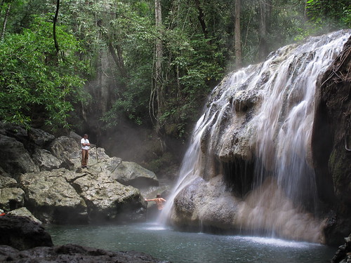
The thermal delights of El Paraiso Falls
I’ve recently been having trouble with some recurring back pain, so luxuriating in thermal waters was just what I needed. Totally uncommercialised and beautifully set, the thermal waterfall at El Paraiso is just that; steaming hot water tumbles about 15 foot down into a fresh cold stream that pools at the falls base. The water really is hot so it’s a real blessing to have a cold plunge pool to intersperse the ‘treatments’ with. To have that piping hot water falling from a height and pummeling my problem back was positively a divine gift. And by clambering up around the side of the falls I was able to find myself a spot away from the biting little fish that seem to prosper in the waters directly beneath the falls. Two very relaxed souls cycled out of El Paraiso, but the bliss was short lived… Justin got a puncture within a hundred feet.
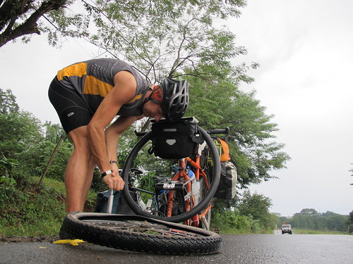
Justin works his puncture repair magic just down the road from the falls
After a night next to Lago de Izabal in El Estor we waved goodbye to the paved road and opened faces and lungs to the dusty delights of 46 unpaved miles into La Tinta. The road was generally in pretty good nick and sustained a fairly steady flow of traffic, something I came to detest on the particularly dusty stretches. Somewhat bizarrely, we also came across a long stretch of road works going into La Tinta where they’re laying a new concrete surface. There were some undulations but with only 2240 feet climbed in the day, nothing major. However, I was never able to settle into the day, unnerved by men in the back of trucks sporting bullet proof vests, armed guards travelling in many of the vehicles (even the back of motorbikes) and suffering with an uncharacteristic bout of bikers arse.

Near the start of the day up to Tactic… everything within a couple of feet of the road is covered in dust
Day three is where the fun started, climbing through the rain up into cold climates like I haven’t experienced since cycling out of Flagstaff early last spring. The first miles out of La Tinta were hot and dusty. With work being carried out on the road it was largely impassable to vehicles giving us a break from the dust clouds. Following seventeen miles of slight incline the days climbing really started around the town of Tucuru. By this point I was undoubtedly back amongst the mountains of Guatemala, a sensation that thrilled me almost to a point beyond saddle pain. Rain arrived during lunch at the peak of a climb out of Tucuru and would follow us most of the way up the long push towards Tactic.

One of our first inklings of the topography ahead as we head away from El Estor
It was a long afternoon with some quite testing grades on slick rain lubricated dirt road. Forging up through countless villages and a few small towns I found most people to be supportive of my efforts. However, it was an effort to block out the constant calls of ‘gringo, gringo… hey gringo‘ and some people are just idiots. Cold wet and exhausted the last thing you need is little fuckers literally laughing in your face. Human idiocy undoubtedly transcends cultural differences, a theme I shall return to later in this post.

The Christmas market of Tactic
Having climbed nearly 6,000 feet over 37 miles, all on unpaved surfaces, the friendly little town of Tactic came at just the right time. A Christmas market sprawled across the central plaza and beneath the Gallo beer sponsored town Christmas tree people were buzzing around in excited anticipation of the coming festivities… they REALLY love Christmas in Guatemala. A cold and damp 16 degrees Celsius (the voice of someone who’s spent too long in hot parts), the rare treat of separate hotel rooms and our new favorite, Hawaii Five-0 on the television… we’d made it up into the highlands, now it was time to enjoy what we’d earned.
Tactic to Cubulco – 54 miles and 5350 feet of climbing in 2 days
The hope, as always, was to hit up as much dirt road as possible, a desire that was vindicated by 8 miles on relatively busy highway south-east out of Tactic. Fortunately our chosen unpaved minor road branched off south at this point, around the small town of Purulha. The road started harshly with a steep incline up to the crest of some mountains before diving down to a small river where we lunched in the rain. After fording the river in bare feet we’d recross tributaries of various sizes again three times in the coming mile, each crossing preceded by a steep incline and followed by climbs that had me off the bike and pushing. It was around one of these that we encountered a heavily armed military vehicle coming the other way; the soldiers looked at us the same way we looked at them… ‘what are you doing here?‘.
Our road drops down towards Salama
Three quarters of the way up what turned out to be our final climb of the day, my period of mechanical bliss gave way to the start of a new era. My rear tire blew out and upon inspection it became clear that not only did I have a tube so severely gashed it could not be repaired, but a rip in another tire (which I now know to be terminal) and to top it all off, my first broken spoke of the tour. Happy Days! Fortunatley, Justin, who usually speeds along way ahead of me, was in earshot so I was able to call him back. To my extreme jealousy he owns a far superior bike pump that makes fixing punctures almost a pleasure. In the absence of detailed maps and route information we both began to fear for the future of the day; time was ticking on and we hadn’t enough water to camp. Unsure of our situation I replaced the spoke as quickly as possible, working only the spokes around the broken one and giving the wheel only a rudimentary truing. It seemed to work fine…

Getting closer to Salama
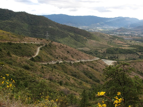
Mechanicals fixed we pushed on to the top of the pass, Justin cycling about twenty feet ahead. At the final ascending turn in the road I witnessed a man get hit in the face by surprise. He stopped and looked in obvious disbelief at what had appeared over the peak in the road. I thought the worst… maybe a guy with a gun, possibly a huge gnarly climb. When I joined him it was obvious, spreading out below our feet was a broad and lumbering valley into which nestled the town of Salama. Beyond the small urban blip pulsed wave after wave of gorgeous Guatemalan mountains. If only my tire had blown a few hundred feet later I would have been able to fix my wheel up properly.

Salama puncture mended we can finally move on towards Rabinal
The road wasn’t in such good condition on the at times steep descent down to Salama, so it took us up to past 5pm before we were settling into our basic hotel room. The next morning we set off with the renewed optimism of young love having both spent the previous evening transfixed by a Shakira concert showing on TV. Eyes agog, mouths open, drool spilling down into our Chilli and rice, we were smitten. Since the start of the tour I’ve held the tongue in cheek belief that I’ll find a wife in Colombia… I hope Shakira can ride a bike as well as she swivels those hips!


Cause and effect… truing my wheel after mending a broken spoke in San Miguel Chicaj
Reality struck home pretty quickly when I managed to ride over some glass and puncture my front tire before even getting out of Salama. Annoying as I was paying special attention to avoiding it and bad enough to require another new tube, but these things happen. They happen with the same inevitability as bad mechanical workmanship coming back to haunt you… I had another spoke break shortly after leaving town. It was the one directly opposite the new one I’d put in the afternoon before… lesson learnt. As Justin made himself at home with a bottle of Coke, I set about giving the residents of San Miguel Chicaj something to talk about. This time I did the job properly, loosening off the entire wheel before going through the truing process in full. It seemed to work and a couple of hours later we were powering our way up the paved road that would drop us down into Rabinal. From there we were surprised to find another stretch of pavement out to Cubulco, to all intense and purposes the end of the road.
Cubulco to Joyabaj – 23 miles and 4700 feet of climbing in just over a day
My map showed no roads coming out of Cubulco other than the one we took in. Justin’s map showed the possibility of a ‘seasonal track’ south out of town over the mountains to join the road west to Quiche (also not on my map). Our spirit for adventure had been sparked by what Ian Benford had written in his ‘Cycle Central America‘ book (available here in pdf). On routes out of Joyabaj he writes: ‘A challenging ride would be the climb over the mountains to Cubulco, this has been explored on foot but not all the way, so better to ask advice locally on track conditions.’ So that’s what we did, arrived in Cubulco and started asking questions and scoping out a route. There was a suggestion it was impassable but the general consensus was that there were options over the mountains to either Pachalum or Joyabaj via the village of Tres Cruces which lies over 3,000 feet above Cubulco (itself at 3258 feet elevation).

Not far out of Cubulco we came face to face with the mountain we’re about to cycle over
After a night in a prison cell, I mean hotel, we were on the bikes by 7:30 and seeking out our path over the mountains. With hindsight I can say with a certain amount of reliability that there are two tracks out of Cubulco up to Tres Cruces, one that mounts a ridge, climbing steeply but steadily to be joined near the summit by the other that goes hell for leather straight up the mountain. We took the second course and judging by how the road surface improved immeasurably when the tracks eventually merged, I’d take an unqualified guess at predicting the other way to be slightly kinder.
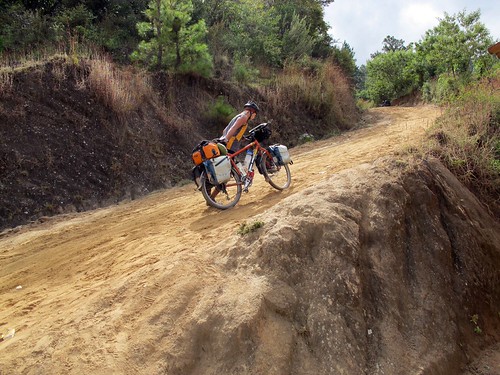
Justin enjoys a bit of pushing… it only got more challenging
We reached the start of the track by dropping down a road on the west side of the plaza at the south end of Cubulco. This then took us west a little way along a river before dropping down to ford the water and start the climb. I now know all too well that serious climbs seem to start by wading shoeless through cold river waters. This was no exception. Straight out of the water the masochistic enjoyment started and I was pushing the Shermster up a sandy high-graded pathway resembling a road. This general theme would continue for about 7 miles on a gradient averaging about 11% over the whole climb. There were long stretches, particularly near the top, where the grade was regularly exceeding 20%. On these sections we were forced to team up, pushing one bike up together before returning for the other. Twice we discovered very short paved sections (a few meters) where the grade was too extreme to hold any other kind of surface.

Looking down on Cubulco from the point where we reached the ‘other’ road
A voyage into the unknown, we attacked the route with a full complement of water; 2.5 litres in our bottles and another gallon each in our dromedary bags. We needn’t have pushed this extra weight as there were a couple of tiendas on route and a good clean water source in the stream that appeared after 5.2 miles of riding/pushing out of Cubulco. Others thinking about this route may want to also take note that the main climb was completed where our track joined the other route, after around 7.4 miles and 2410 feet of climbing. At 8 miles and 2600 feet climbed the route crosses to the other side of the mountain and then into Tres Cruces at 9.7 miles with 2900 feet climbed. In the end we had no problems at all in navigating as there were so many kind and friendly folk along the way only too happy to tell us we were crazy and that as crazy people we should go this way or that.

Riding into Tres Cruces… climb completed
From Tres Cruces the road fell dramatically down to the bottom of the valley on the other side of the mountain to join the asphalted road into Joyabaj and onto Quiche. The grade wasn’t as extreme as the climb up and the road generally really good dirt and gravel. With the sun dropping into fragmented cloud before us it was a delightfully picturesque descent. Our hope had been to camp up on the descent but there were houses and people everywhere (much like the rest of the country). A bit washed up from our efforts earlier in the day we knew Joyabaj was beyond us that night and asked a farmer to pitch up across the road by a river. He was delighted to oblige and no doubt headed the small gaggle of guys that watched from afar as we set up and settled in.

Descending down from Tres Cruces
Joyabaj asked another 6 miles of us the next morning. Although now on good paved road surface this short distance was packed with more high-grade climbing. The sun had decided to make the sky its own so those first miles were a hot and sweaty toil coloured by the lactic acid burning in my legs from the day before. Experience has taught me to be conservative in my riding style so it’s a rare thing for my legs to burn and my energy to drop. The rest of this day was a reminder of why I ride like I normally do.
Joyabaj to Xela – 80 miles and 8,700 feet of climbing in 2.5 days
Learning from Ian Benford that the road from Joyabaj to Quiche would be paved was one of the factors that influenced our choice to ride the route we did through Cubulco. In fact, we now know that the entire route from Joyabaj through Quiche and Totonicapan to Xela is lined with good pavement (we also now know there may be another road west out of Cubulco). Coming off some challenging dirt roads it’s all to easy to dismiss the prospect of riding pavement as an effortless stroll in the park. The ride into Quiche is in no way spectacularly challenging, but on the back of our previous days the 38 miles and 5500 feet of climbing from a few miles before Joyabaj were a test. Reasonably high grades kept cropping up to remind me of my dwindling energy reserves.

The central church of Quiche
I have previously made reference to the two main points I took with me from this stretch of riding. Firstly that although much of Guatemala is mountainous, there are people living just about everywhere. This shouldn’t really come as much of a surprise given the relatively small size of the place (about the same size as England) but with its high rural population is deceptively so. Everywhere there are villages and towns and between them are farms and ranches, all of which have contributed to Guatemala’s big deforestation problem.

Having dropped out of Quiche the road soon starts to climb
The second branch of my days thoughts developed after a little brat decided it would be a good idea to hit me with a stick as I rode past. There is no excuse for such mindless behavior. I have not seen anyone else hitting people with sticks in Guatemala and thus this can not (as some would like) attribute such actions to cultural differences. The reality is that it doesn’t matter where you are in the world, there are always good kids and obnoxious ones, good parents and bad, kind people and mean. That little fucker is lucky he just got a shouting at and dose of choice finger pointing… I should have given him a taste of Alaskan bear spray. Such episodes act as a reminder that we are all humans in this world and within societies there are the same faults and issues that replicate despite the circumstance. It is all too easy to romanticise cultures according to what we hope; that person is wearing traditional dress so they must be innocent and poor… not so, they’re just like you with all your foibles.

As it climbs higher more and more small farms appear
With a certain amount of time to kill before starting a months worth of Spanish language school in Xela we decided to split the ride from Quiche to Xela through Totonicapan into two days. Peaking out at 9396 feet of elevation before the drop down into Totonicapan it would take us up to the highest altitude of the leg and would inevitably involve a fair amount of climbing. In the end I encountered some more mechanical problems that slowed me down enough to make our planned night in Totonoicapan unavoidable anyway.

Eventually the farm land dies out to be replaced by pine forest
Before cycling out of Quiche I was fully aware of the 6 mile, 600 foot drop down to 6,000 feet and subsequent 17 mile climb up to the before mentioned high point. What wasn’t on the menu was the unnerving spoke noise I was getting out of my problem rear wheel (the rim got misshapen after a tire blow-out in Mexico that now means one side of spokes has to be considerably tighter than the other) and the rear puncture that hit me at midday whilst still at only 7,500 feet. I’d just caught Justin up for a quick break and at the restart had let him get out of view (my compromise in missing the sensation of solo riding) before starting off again myself. WIthin a couple of hundred yards the tire quickly deflated and I jumped back into my now all too familiar mechanic mode. While at it I also went around tightening all the spokes on that wheel before quickly truing it again. Joined by a man and his young lad who became more than a little annoying with their rather too thorough investigation of my luggage and nearly joined by a drunk guy who thankfully fell off the road and passed out amongst the maize before reaching me, I was forced into fleeing early with only a half inflated tire. I stopped around the corner only to be reminded once again just how ineffective my bike pump has become. In the end I moved off a good couple of hours after stopping for a break. It came as no surprise a little later when a passing motorist assured me that Justin was already waiting for me at the summit.

After the climb we finally drop down into Totonicapan
I eventually beavered my way up the climb to rejoin a by that time rather cold Justin before descending into Totonicapan where we’d spend an exhausted night. The town was absolutely jumping with the rhythms and expectations of Christmas. I was absolutely not. In actual fact, it turns out that I appear to have picked up a bit of sun stroke… not a bad effort on the shortest day of the year! That night I did manage to muster enough energy to work on my rear wheel again, this time loosening off the spokes I’d tightened and paying particular attention to the uniformity of spoke tension. It appeared to work as the twenty miles into Xela the next day were ridden without any spoke noise… I did get another rear puncture though. And this was not the end of my mechanical woes. The Rohloff gear shifter periodically ceases making changing gear really hard, this usually occurs after riding in the rain. I’ve got used to cleaning and fiddling to free this issue up. Unfortunatley, riding into Xela the problem escalated into becoming a major disruption. I could only reach gears 5 and 6, making hills a very real challenge. I felt like I’d left my dignity in a steaming pile at the foot of the hill when I was forced to get off and push my bike up a busy stretch of road in Xela.

My mechanical issues followed me all the way into Xela
So that was that. It’s been a great period of riding in a beautiful country, a stretch that has left me with a lot to sort out on the bike. Thankfully I now have a month to do so as I’m registered for a month of Spanish language tuition with Utatlan Spanish school here. A school that I was strangely set up with after my mother met the mother of the lady who owns and runs it when down in Peru. In four weeks I’ll resume the quest south, hopefully with a full complement of fully functioning gear and having made some difficult decisions.
